

D03D
Eldon, WA, USA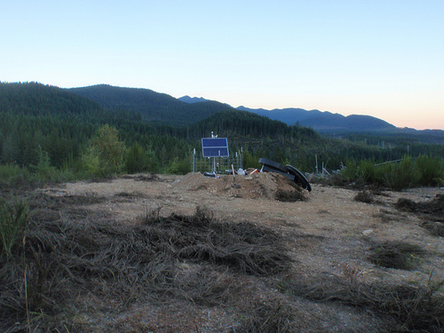
The USArray component of the NSF-funded EarthScope project ended its observational period in September 2021 and all remaining close-out tasks concluded in March 2022. Hundreds of seismic stations were transferred to other operators and continue to collect scientific observations. This USArray.org website is now in an archival state and will no longer be updated. To learn more about this project and the science it continues to enable, please view publications here: http://usarray.org/researchers/pubs and citations of the Transportable Array network DOI 10.7914/SN/TA.
To further advance geophysics support for the geophysics community, UNAVCO and IRIS are merging. The merged organization will be called EarthScope Consortium. As our science becomes more convergent, there is benefit to examining how we can support research and education as a single organization to conduct and advance cutting-edge geophysics. See our Joining Forces website for more information. The site earthscope.org will soon host the new EarthScope Consortium website.

The success of the Transportable Array experiment requires the participation of hundreds of landowners who allow seismic stations to occupy their property for somewhere between 18 and 24 months. In fact, private landowners are by far the biggest number of Transportable Array participants. USArray works with local universities to find and sign up landowners who are willing to host a seismic station. There aren't enough seismometers to cover the whole United States at one time, so the first group of 400 seismometers was deployed in the western part of the United States. When this deployment was completed, the seismometers moved to the next swath of states to the east. This “rolling” deployment will continue until the whole United States is covered. Regional networks sometimes adopt a station for permanent installation.
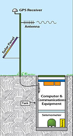
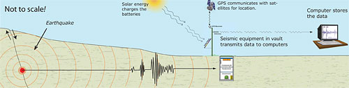
A USArray seismic station consists of a seismometer, data acquisition system, and communication equipment buried in a sealed, thermally insulated chamber, or vault, about six feet below the surface. The seismic station also includes a solar panel to power the batteries and a freestanding communications module to transmit real-time data via satellite, phone, or Internet.
The buried seismometer is the key instrument at a seismic station. It detects and measures Earth's ground motion. These vibrations are similar to sound waves in air, but span a wide frequency range that extends well below the threshold for human hearing. The seismometer's sensors are extremely sensitive and can pick up a broad spectrum of motions ranging from low-amplitude background vibrations, such as those generated by wind or pounding surf, to signals from local, regional, and distant earthquakes. The sensitivity of the station depends on how quiet the local conditions are--the lower the "background noise" from human and natural sources such as traffic and swaying trees, the more likely the station will be able to detect faint earthquake signals. Sites are chosen to minimize the background noise as much as is practical, while still allowing access for the installation of the equipment.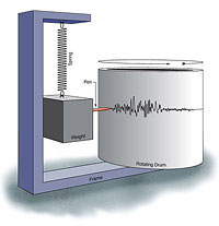
The seismometer, which is a little larger than a one-gallon paint can, contains delicate moving parts and sophisticated electronics, but operates on a very simple principle. The motion sensor consists of a weight hanging on a spring that is suspended from the frame of the seismometer. When an earthquake occurs, the suspended weight initially remains stationary while the frame moves with Earth's surface. The relative motion between the weight and Earth provides a measure of the ground motion. Three sensors are combined in a single package to measure ground motion in three dimensions.
Modern seismometers, like those being used by USArray, use a complex feedback system to measure the ground motion electronically. The signals are converted to digital records, which are then stored on a computer in the vault. These data are transmitted continuously to EarthScope data processing centers by cellular telephone, broadband Internet, or satellite communications systems. The type of communications system chosen depends on the conditions at the site and in the surrounding area. Once the data are received at the processing center, they are automatically indexed and immediately sent to the IRIS Data Management Center where they are stored and made available via the Internet to researchers and the general public.
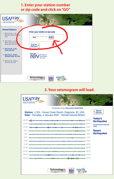
Go to the USArray Station Monitor page and type in your station number or zip code and click on "GO." A 24-hour seismogram for the station you selected will appear.
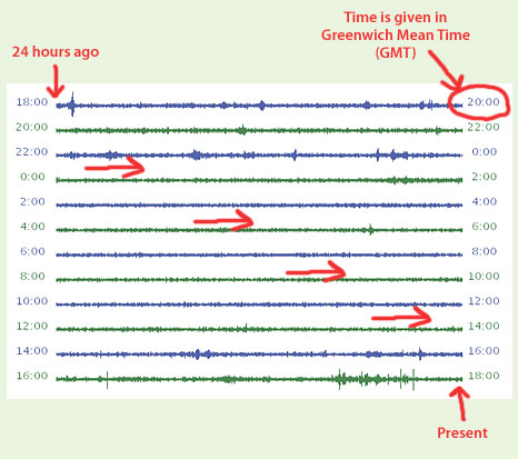
The seismogram shows data from 24 hours ago to the present. View the lines from left to right starting at the top line and moving down. The top line shows the oldest data. The bottom line shows the most recent.
The times shown down the sides are in Greenwich Mean Time (GMT).
Note that the seismogram is showing only vertical ground motion, although each station has three sensors to record ground motion in different directions (vertical, north-south, east-west). Measurements are taken 40 times per second.
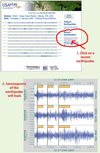
If there have been any recent earthquakes recorded by your station, they will be listed on the right of your seismogram. Click on the earthquakes listed to see their seismograms.
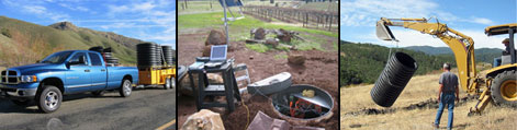
Construction of a Transportable Array site requires the use of a small backhoe, a small cement mixer, a 6-foot-long piece of 42-inch diameter plastic drainage pipe, and an assortment of other equipment. Materials for dozens of stations are sent in advance to a storage depot where the construction and installation teams access the equipment as needed. The trucks can haul materials for multiple sites, so a three-person construction team using three vehicles, one trailer, and one backhoe can construct four sites in five days before returning to the storage depot.
Field operations related to the installation of the Transportable Array are performed by small teams of contract personnel under the direction of IRIS staff. Meet the Lead Construction Engineer.
Imagine you are a geoscientist who studies active volcanoes. You want to know if the magma chamber of a particular volcano is near the surface, suggesting an eruption in the near future. Or, you are a seismologist who needs to understand the earthquake potential in Southern California and so wants a subsurface map of the faults in the region. Seismic imaging offers the ability to "see" structures that are deeper than we can otherwise study.
The process of making three-dimensional images of Earth's interior using seismic signals, called seismic tomography, can be likened to the three-dimensional imagery of a CAT scan. A CAT scan (Computed Axial Tomography) generates a three-dimensional image of the brain by stacking a lot of flat, two-dimensional X-ray pictures. The basic idea of a CAT scan is this: the X-ray beam moves all around the patient, taking images from hundreds of different angles. A computer takes the information and puts together a three-dimensional image of your inner soft tissues. The X-ray beam is the energy source, which sends its signal (electromagnetic radiation) to the receiver (film), which captures and stores the data.
With seismic tomography, the energy source is the earthquake. An earthquake's seismic waves are recorded by many receivers (seismographs). Unlike an X-ray beam that shoots in one direction, thus requiring a doctor to aim the beam numerous times to get views at multiple angles, an earthquake radiates seismic waves in all directions. Instead of having to move the energy source around to get views from all angles, seismologists use earthquake data recorded at multiple receivers to map Earth's interior. The more receivers you have, the more detailed your three-dimensional image will be.
At the end of September 2007, about 2.7 terabytes (2,700,000,000,000 bytes) of data from Transportable Array stations have been collected. On average, a 300-page book is about 1 megabyte (1,000,000 bytes), so the amount of seismic data collected thus far is equivalent to more than 2.5 million books; for comparison, the Library of Congress has 29 million books.
EarthScope facilities will produce data at a rate that only a decade ago would have overwhelmed the technical capabilities of the geoscience community. USArray alone produces almost 5 terabytes of data per year.
These data are transmitted in real-time to the EarthScope Array Network Facility at the University of California, San Diego with minimal delay via satellite, cell phone, and Internet, and archived at the IRIS Data Management Center in Seattle, Washington. These data can be accessed by anyone.

