

TIGA
Tifton, GA, USA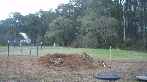
The USArray component of the NSF-funded EarthScope project ended its observational period in September 2021 and all remaining close-out tasks concluded in March 2022. Hundreds of seismic stations were transferred to other operators and continue to collect scientific observations. This USArray.org website is now in an archival state and will no longer be updated. To learn more about this project and the science it continues to enable, please view publications here: http://usarray.org/researchers/pubs and citations of the Transportable Array network DOI 10.7914/SN/TA.
To further advance geophysics support for the geophysics community, UNAVCO and IRIS are merging. The merged organization will be called EarthScope Consortium. As our science becomes more convergent, there is benefit to examining how we can support research and education as a single organization to conduct and advance cutting-edge geophysics. See our Joining Forces website for more information. The site earthscope.org will soon host the new EarthScope Consortium website.

By Maia ten Brink
The Pacific Northwest is due for a catastrophic earthquake. Offshore from Washington State, the Pacific Plate is grinding slowly eastward, forcing the Juan de Fuca Plate under the edge of the North American Plate. This region of clashing tectonic plates is known as the Cascadia subduction zone, a hotbed of seismic activity that has spawned mountain ranges, volcanic eruptions, and earthquakes. A large earthquake in Cascadia could trigger tsunamis and landslides that would devastate Seattle, Puget Sound, and the Pacific Rim. In a region as soggy as the Pacific Northwest, tremblors could also shake the soil loose and induce deadly landslides. The last megathrust quake, in 1700, generated a tsunami so large that it battered the shores of Japan.
The Pacific Northwest Seismic Network (PNSN) monitors Cascadia’s seismic activity and provides early warnings of seismic hazards. In 2009, the PNSN “adopted” 18 seismic stations in Cascadia from the USArray Transportable Array (TA), a temporary seismic network of more than 500 stations that has measured ground vibrations across North America. The TA handled land permitting, construction, and installation in exchange for the cost of the station equipment. Now the PNSN is working on integrating the adopted TA stations into their operations.
On a gray March morning in 2014, one of the TA field engineers, Howard Peavey, accompanied two PNSN technicians to an adopted TA station in Marblemount, WA. MRBL seismic station—formerly TA station B06A—is buried in a meter-wide, three-meter-deep plastic vault in a private landowner’s back field. It lies at the foot of the North Cascades, a mountain range collaged out of volcanic islands, ancient continents, ocean bottom basalt, and mantle rock that were melded together under huge pressure deep inside Earth and then thrust upward.
Peavey needed to hand over a piece of a equipment called a digitizer so that Lynn Simmons and Karl Hagel from the PNSN could install a new seismic sensor in MRBL. Sharing equipment and knowledge is one of the TA’s central tenets. A team of TA field engineers travelled to Chile following the February 2010 earthquake to help establish a permanent network of seismic sensors. Members of TA’s operating team routinely collaborate with smaller networks like the PNSN. The TA’s “adopt a station” program has even led to the creation of a new seismic network consisting of 159 stations along the Atlantic seaboard, a kind of East Coast mirror network to the PNSN that is called the Central and Eastern United States Seismic Network (CEUSN).
Peavey, Simmons, and Hagel took the North Cascades Highway towards Marblemount, winding alongside the Skagit River. Their windshield wipers beat a frenzied rhythm. With the downpour of the past few days, the river had swelled and swamped up the fields. Peavey predicted a very damp excursion to the station.
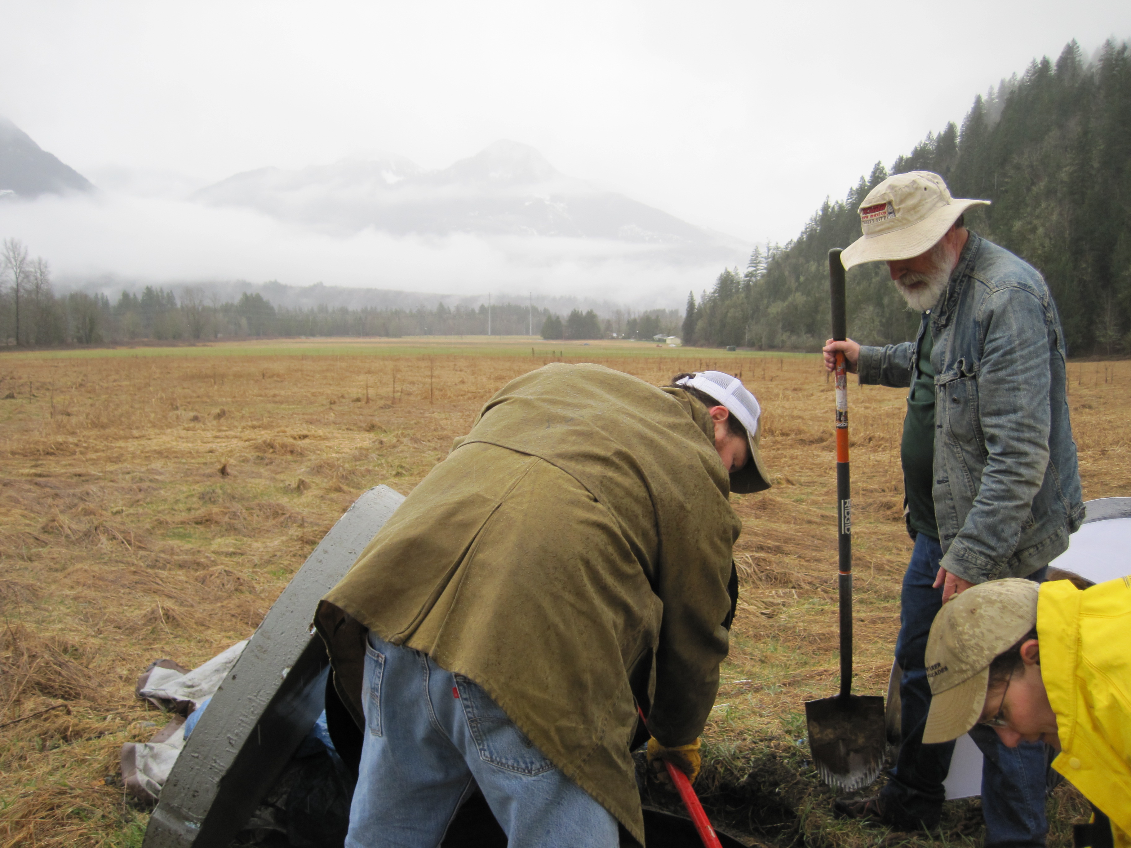
Howard Peavey (with shovel) plus Lynn Simmons and Karl Hagel
from the Pacific Northwest Seismic Network working on an
adopted TA station in Marblemount, WA.
During the drive, Simmons explained that many of the PNSN’s seismometers are deployed on school and government grounds around Washington and Oregon. If you want a school to host a seismic station, she confided, ask the janitor which teacher is the most enthusiastic science nerd. Fortunately, all the landowners who originally agreed to host TA stations for a two-year stint agreed to participate in the PNSN’s long-term network.
The car braked suddenly, sliding on a sheen of mud that covered the one-lane highway. A fresh sludge-stain and splintered boughs marred the pavement; the mudslide must have just happened a few minutes earlier. Several downed trees poked into the opposite lane.
Unexpected obstacles and foul weather are the daily reality of running a seismic network. Peavey keeps boots and a sleeping bag rated to 0°C in his car in case he gets stuck along some country road.
Peavey and the PNSN technicians continued more carefully onward to the landowner’s property in Marblemount. They parked about half a kilometer away from the buried station vault rather than sink their vehicles in the muck. Simmons pulled on bright yellow rain pants and a slicker, Hagel shrugged on his coat, and Peavey set a floppy fishing hat on his balding head. They set out across the fallow field laden with laptops, the digitizer, paper towels, rags, shovels, tarps, and umbrellas. Peavey loped along with a blue 11-liter bucket filled with six cans of urethane foam and a wide shovel. “Life is too short for a little shovel,” he quipped.
The vault that housed the seismic equipment was buried about three meters from a solar panel mast, which powers the station. Hagel excavated the chained black lid of the vault, then propped it up with a shovel and draped a green tarp over it to shield the vault from the rain.
There was just enough space inside for Simmons to kneel inside without bumping against the metal shelf that housed a row of computers.
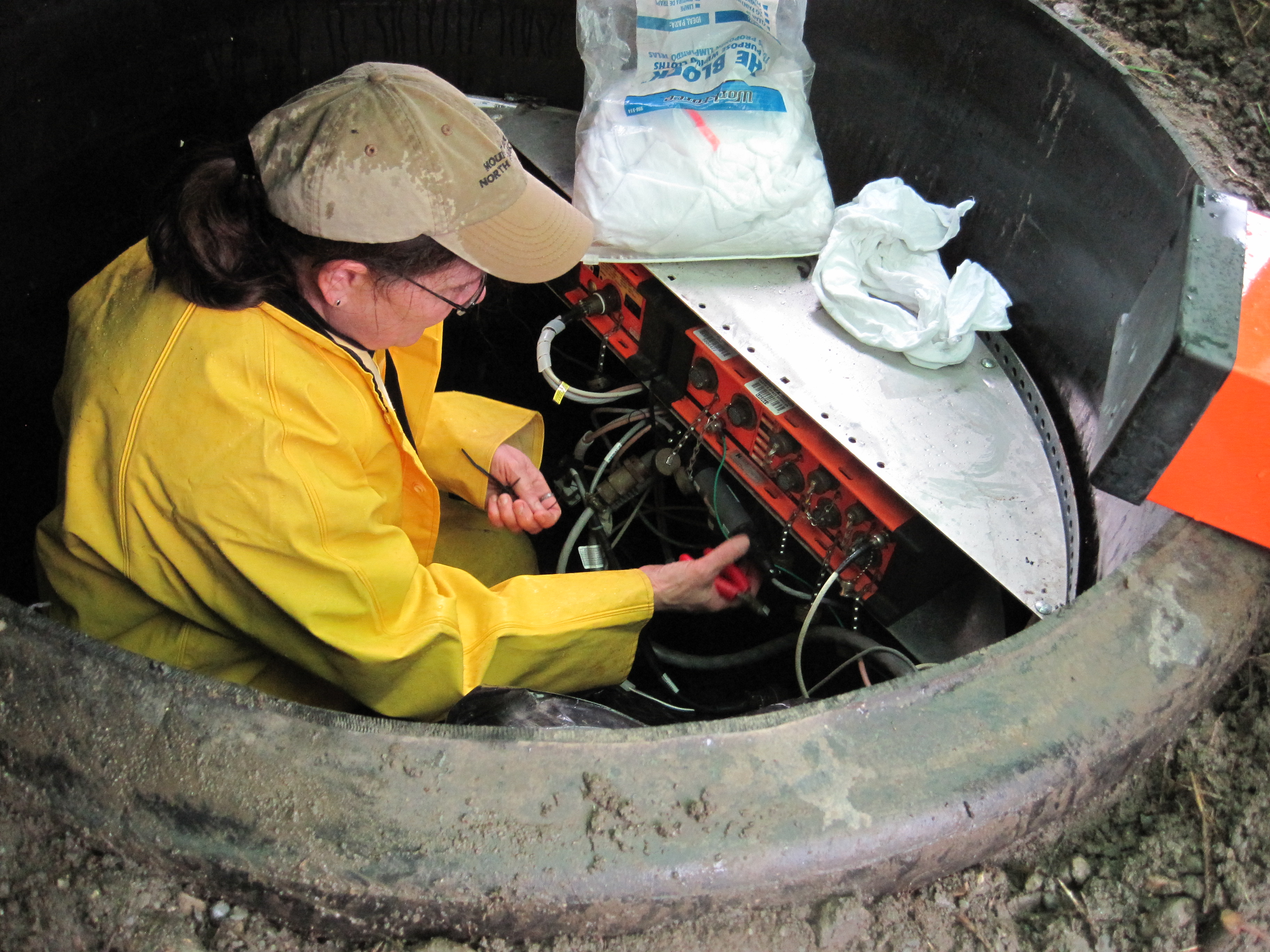
Lynn Simmons working inside the TA vault.
Peavey handed her the six-channel digitizer, a boxy orange computer with black rubber encasing the corners and six input sockets that look like surprised faces. The digitizer transforms voltage information about the velocity and acceleration of the seismometer’s moving parts into measurements of the strength of an earthquake.
Simmons needed the six-channel digitizer to hook up to a seismometer called a strong motion sensor. Strong motion sensors pick up vibrations large enough to cause structural damage, while broadband sensors record tiny vibrations from weak or distant sources. MRBL station has both. A strong earthquake can throw a person sideways off their feet with more than half the acceleration of gravity—that’s like freefalling sideways. A cat napping on a windowsill will go flying across the room. During earthquakes that powerful, the shaking is far too strong for broadband sensors to measure. All the TA stations are outfitted with broadband sensors, but the PNSN wants strong motion sensors because they are especially interested in preparing for earthquake hazards.
While Simmons worked on installing the new digitizer, Peavey quizzed Hagel about how the adopted TA stations have been faring. After servicing more than 1000 stations, Peavey knows how to troubleshoot almost any problem with a TA station. For every snarl Hagel had encountered, Peavey had an answering anecdote. Shadows on the lower part of the solar panel? Bend the wire fencing down a bit. Signals that look like lightning strikes? Check whether one of the components is overheating. Is it effective to stick the solar panels up in a tree to get more sunshine? Sometimes more trouble than it’s worth.
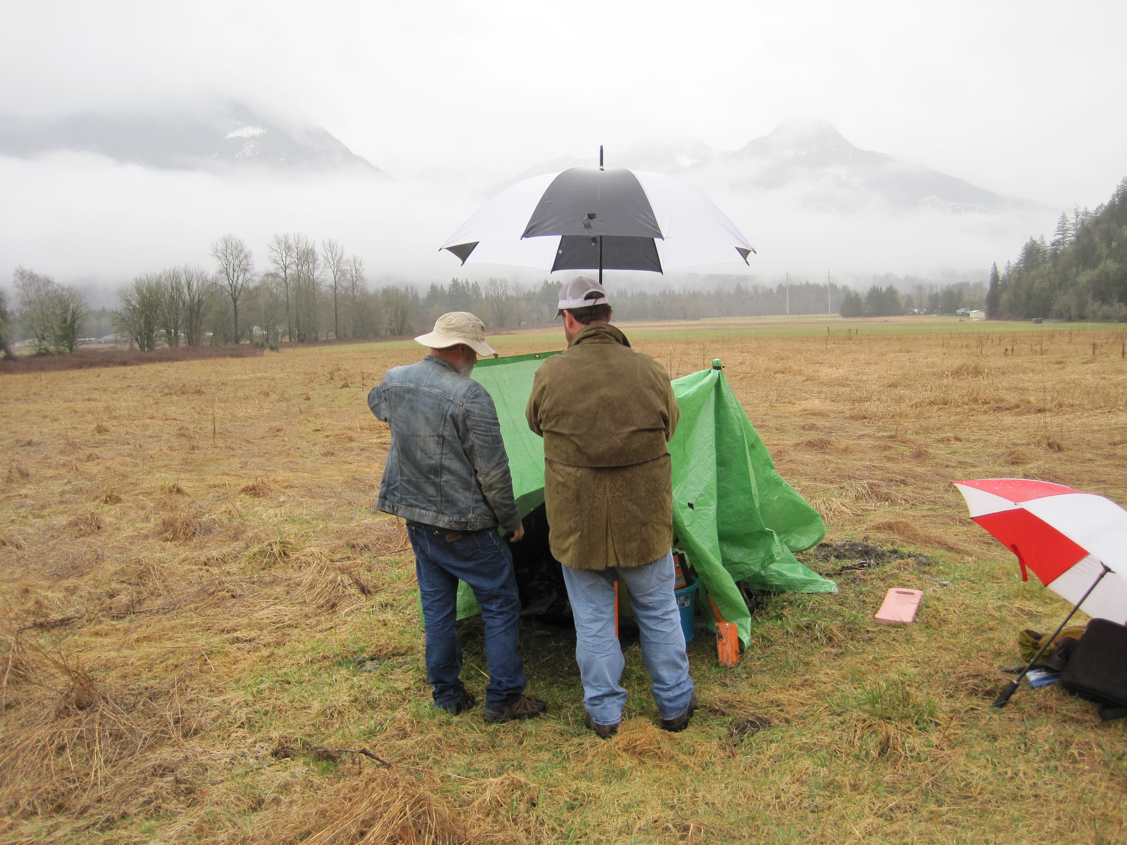
A green tarp shelters the vault from the rain
while the station was being worked on.
“I just try to remember what didn’t work last time and stop doing that,” Peavey said. “It’s empirical. If I’ve seen crazy symptoms in the past, I try to remember and either not do that again or at least remember how it went last time. I don’t have the theoretical education; I just have to live on my wits.”
Finally, Simmons heaved herself out of the vault to let Peavey take a gander. He noticed water dribbling in from a screw hole in the wall of the vault that could foul up the seismometers’ measurements. The temperature and humidity need to remain stable for the seismometers to work properly.
The best method to caulk the ribbed wall of the vault, Peavey told Simmons and Hagel, uses expanding urethane foam. The foam would eject water in both directions, he said, then harden and keep moisture from filling the rib again. He fit the nozzle of a can of foam into the offending leak point. Foam spewed into the space between the ribs and water sputtered out of a screw hole on the other side of the vault.
“When I pull the can out, it is going to belch a big wad of foam,” he warned. It burbled out, the color and consistency of whipped butter on pancakes at a diner, cascaded down around the batteries, and gummed up his shoelaces. “Worse than boogers,” Peavey said. He looked down at his sticky pants. “These were my nicest jeans this morning. Now they are work jeans.”
At last Peavey, Simmons, and Hagel reburied the vault and tramped back to their vehicles, soaked and muddy. MRBL station was now watertight and functional, sending seismogram recordings of ground vibrations—including the technicians’ footfalls—back to PNSN headquarters at the University of Washington. Adopted TA stations like MRBL collect new data so that the Pacific Northwest can prepare for the next big quake.
For more information about how often large earthquakes happen, click here.

