

W18A
Petrified Forest, AZ, USA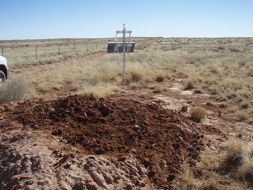
The USArray component of the NSF-funded EarthScope project ended its observational period in September 2021 and all remaining close-out tasks concluded in March 2022. Hundreds of seismic stations were transferred to other operators and continue to collect scientific observations. This USArray.org website is now in an archival state and will no longer be updated. To learn more about this project and the science it continues to enable, please view publications here: http://usarray.org/researchers/pubs and citations of the Transportable Array network DOI 10.7914/SN/TA.
To further advance geophysics support for the geophysics community, UNAVCO and IRIS are merging. The merged organization will be called EarthScope Consortium. As our science becomes more convergent, there is benefit to examining how we can support research and education as a single organization to conduct and advance cutting-edge geophysics. See our Joining Forces website for more information. The site earthscope.org will soon host the new EarthScope Consortium website.

By Maia ten Brink
Every morning, Mike Hamlin gets his coffee, reads his email, checks the weather, and then clicks on the USArray’s station monitor website to see what’s shaking. He downloads a readout of the previous day’s seismic activity measured by an earthquake sensor that sits in his own backyard, USArray Station M49A.
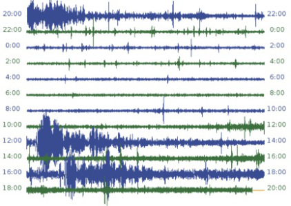
USArray seismogram showing the
February 2013 earthquake in the Solomon Islands.
On Feb. 7, 2013, Hamlin saw a huge spike in amplitude in the seismogram, representing vibrations caused by ground motion. The sensitive seismometer on his farm in northwestern Ohio had registered shockwaves from a magnitude 8.0 quake near Papua New Guinea, on the other side of the world! After a quick search on the United States Geological Survey’s real-time earthquake update page, Hamlin calculated that it had taken just tens of minutes for the waves to travel over 12,500 km from the South Pacific to his farm. He posted a photo of the seismogram on a science blog he curates with his son. “It still amazes me how small our planet really is,” he wrote.
Hamlin was a high school science teacher for 30 years and now teaches biology and anatomy at a local community college. His obsession with Earth science, however, only started in 2011 when a reconnaissance siter with the USArray project called to ask if he would host a seismic station on his property for two or three years. According to Hamlin, the siter initially approached a neighbor, who said, “You will want to talk to Mike. He’s crazy. He will love this stuff.”
The nearest town to Hamlin is Liberty Center, population 1180. It’s a farming community 40 minutes outside Toledo, Ohio. When you drive down the roads, you have to give the tractors, combines, and farm equipment a wide berth. “We laugh at people who just don’t get it…people who are what we call ‘from the city.’” There used to be one red light, but now it’s just a four-way stop. Hamlin’s quiet corn, soybean, and wheat fields provide the perfect location for a seismometer—no highways, rivers, railways, or football stadiums generating vibrations that obscure true seismic activity.
At first, Hamlin says, people worried that he had unwittingly invited an oil company onto his land. To allay their fears, he took a USArray brochure around to his neighbors, explaining that they would see a solar panel out in his field to power the seismometer and a communication antenna to send the data in real time back to California to be processed. Hamlin recalls neighbors asking, “Is it going to cause earthquakes?”
“Good gosh, no!” he replied. “It’s going to measure earthquakes!”
The USArray field crew installed the station in the ground in July 2012, with Hamlin excitedly hovering at the edge of the hole and asking them to explain each piece of equipment. He showed off the new station as proudly as if he had put it there himself. “I told enough people about it that they would start calling me up: ‘Hey, Mike, we heard about the, uh, earthquake there. Do you have it?’” Hamlin would direct them to his blog, where he would post, “This just happened in Russia. This just happened in Iran. This is what happens when a neighbor had a big tree down.” Eventually, with a little education, Hamlin says, people were won over.
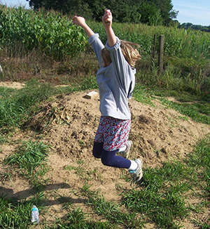
Hamlin’s granddaughter Hannah trying to make waves.
“We were gathered for an engagement party for my son…That was the best day ever.” Hamlin did a hayride and drove a wagon full of kids and adults about 450 meters behind the house to see the seismic station. He instructed everyone to stomp on the ground. Hamlin’s grandchildren, three and eight at the time, had to jump pretty hard for the seismometer to register their stomps. Then everybody went back to look online at the near-real-time station readout. It takes just minutes for the seismometer’s measurements to be sent to data relay centers, filtered, and posted on the web.
“Do you see the difference here?” Hamlin pointed. “Do you see the scribbles? That’s each time you jump! Or when a farmer will go by, like when he’s mowing the hay on his tractor, you could actually see when he circled around. The vibrations would get greater and then diminish, greater and then diminish.” In the nearby town of Edgerton, the next seismometer in the USArray, Station M48A, lies close enough to railroad tracks that Hamlin says he can discern the train schedule just by looking at the waveforms on the seismogram. Even thunderstorms show up on the seismogram. “We had a house explosion about 19 km away and it actually registered. It was amazing!”
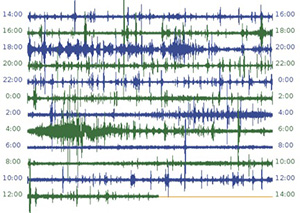
USArray seismogram captures local thunderstorms.
Between his blog and word of mouth, Hamlin estimates that he introduced over 100 people to Station M49A, maybe 200. The USArray project has involved thousands of landowners like Hamlin. Even if only a few demonstrate his enthusiasm, it is a powerful, grassroots way to spread awareness about earthquake research.
“You know what? I think there’s been more earthquakes since they put that thing in,” Hamlin’s friends quipped. “No, it’s just that I’m talking about it more,” he explained. “Now that you have a device to measure it, you are aware more often that things are happening all over the world.”
Hamlin experienced a large earthquake as a kindergartener when his family was living in Turkey. “I swear the ground moved like a water wave; it rose up and fell back down.” In northwestern Ohio, however, he has never felt anything stronger than a tremor. “Nobody really thinks about earthquakes in this area because they are very rare.” He says that his family, friends, and neighbors have learned not to mention earthquakes around him unless they want their ears talked off. “My wife laughs. She says, ‘You’ve got to know when to shut up.’”
Hamlin has followed a few of the discoveries that came out of the USArray data so far. Scientists mainly use the seismic readings to make detailed images of Earth’s crust and mantle beneath North America, but some data can tell them about what is happening beneath Earth’s surface in other parts of the world. Seismologists have also made back-projections, triangulating earthquake sources from the USArray data and showing how earthquake vibrations move across North America like ripples on a pond. Hamlin was astonished to learn that the waves don’t just travel along Earth’s surface (these are called surface waves), but also radiate through the Earth (these are known as body waves). “I still can’t tell a P-wave from an S-wave on the recording,” Hamlin laments, but “I just like looking at what they found.” He says he’ll leave the questions to the pros.
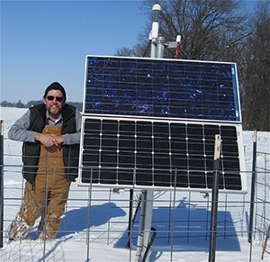
Hamlin at the USArray solar panel on his farm in northwestern Ohio.
For more information about earthquakes, visit IRIS’s education and outreach links at http://www.iris.edu/hq/programs/education_and_outreach

