

I04A
Tendick Farm, Oakridge, OR, USA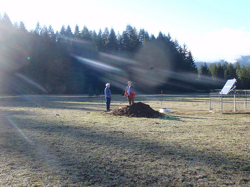
The USArray component of the NSF-funded EarthScope project ended its observational period in September 2021 and all remaining close-out tasks concluded in March 2022. Hundreds of seismic stations were transferred to other operators and continue to collect scientific observations. This USArray.org website is now in an archival state and will no longer be updated. To learn more about this project and the science it continues to enable, please view publications here: http://usarray.org/researchers/pubs and citations of the Transportable Array network DOI 10.7914/SN/TA.
To further advance geophysics support for the geophysics community, UNAVCO and IRIS are merging. The merged organization will be called EarthScope Consortium. As our science becomes more convergent, there is benefit to examining how we can support research and education as a single organization to conduct and advance cutting-edge geophysics. See our Joining Forces website for more information. The site earthscope.org will soon host the new EarthScope Consortium website.

By Maia ten Brink
It’s a nondescript entrance in Seattle’s University District, the kind of shadowed door that your eye slides over as chattering students and harried bicyclists rush past. You would never know that it houses the Library of Alexandria of earthquake data.
The Data Management Center for the Incorporated Research Institutions for Seismology, otherwise known as the IRIS DMC, is an archive and clearinghouse of global earthquake recordings. It’s the long-term home of every earthquake recorded by EarthScope’s USArray, an experimental seismic network of almost 500 seismometers that were sequentially deployed for two-year stints all over the United States during the last decade. Eventually, when the last USArray stations are long gone, students and academics will still be able to study Earth’s interior structure using high-quality USArray recordings downloaded from the DMC.
A team of seismologists, Web developers, and analysts at the DMC keep millions of seismograms electronically “stacked and shelved” so that anyone can easily access them online. The stewards of the USArray data set include Gillian Sharer, an analyst who sifts through seismic waveforms and ensures that the instruments are accurately capturing Earth’s motion. Manoch Bahavar and Alex Hutko create visualizations and data products to aid other scientists in analyzing massive quantities of seismograms. Sarah Ashmore archives the data, ensuring that they are packed correctly, without gaps or broken files.
The old model of scholars visiting observatories and libraries to pore over charts is obsolete. Now scientists can download terabytes of data at the click of a mouse. Hutko compares it to the rise of online movie streaming and the demise of VCR rentals. “Decades ago, seismologists were happy to look at one or two or tens of seismograms,” says Chad Trabant, who manages the USArray team at the DMC. “That age is diminishing. The number of problems that you can address with that few seismograms or recordings is quite small compared to what you can do with a lot more data.”
Tim Ahern, the director of the DMC, has overseen data services for the IRIS for 26 years.
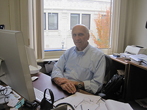
Tim Ahern, the director of the IRIS Data Management Center
His wedding ring has a seismogram etched onto its inner surface. Under his leadership, the DMC has pioneered open access to seismology so that anyone anywhere in the world can obtain and play around with data. Not only does IRIS make data freely available, it also lends out seismic instruments for any researcher to do fieldwork through PASSCAL, the Program for Array Seismic Studies of the Continental Lithosphere. “IRIS totally changed the field of seismology,” says Ahern. “The big science used to be done by big institutions. Now the big science can be done by any individual seismologist in any institution. Little universities now participate on a level playing field… We changed the way our science is done, and that has tremendous impact.”
Bahavar, Hutko, and the other developers at the DMC generate tools, visualizations, and charts to help seismologists digest and analyze large volumes of data. One type of animation that Bahavar created, called ground motion visualizations, demonstrates how waveforms travel across Earth’s surface. Just like when you toss a rock into a pond, earthquakes generate energy in the form of seismic waves that ripple out from the source in concentric circles. With seismic stations evenly spaced every 70 km around the United States, USArray is the ideal scale to reveal those rippling seismic waves.
One of Bahavar’s ground motion visualizations combines seismograms from hundreds of seismic stations over the course of ten years. Colored dots representing each station flash red or blue to represent upward or downward ground motion. When you press play on the animation, alternating bands of red and blue sprout in Southern California and shudder across a map of the United States.
“That ground motion visualization page is so easy to use,” says Graylan Vincent, whose job it was to convince private landowners to host USArray stations on their properties. He would show landowners the DMC animations, he said, to emphasize how their contribution to the USArray experiment translated into new scientific insights.
Other data products include back-projection movies showing the sources of earthquakes based on how seismic waves propagated through Earth, software to transform seismograms into audible sounds, and figures showing how infrasound, low-frequency sound waves detected by USArray stations, travel through the atmosphere.
After Hurricane Sandy, Hutko created a visualization that showed the storm blowing across the USArray. “We have this big super-array taking up a good chunk of the US and it can do things like see the effects of a hurricane, in addition to picking up earthquake data,” says Hutko.
When major events happen, the DMC creates special Web pages with graphics illustrating how faults rupture or how low-pressure airwaves from landslides and storms register on seismic networks. “We try to galvanize the community by collecting disparate pieces of informal or very quick research and put them into a Web page that is a one-stop shop for all preliminary results,” says Hutko. Those Web pages get cited and circulated by news media. “I got onto the front page of Yahoo,” he says.
Another crucial role the DMC plays is in quality controlling the data that streams in 24 hours a day from the USArray seismic stations.
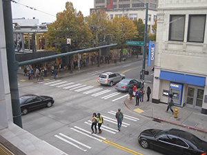
A view of "the Ave" from the DMC offices in Seattle
Every morning, Sharer runs software custom made by the DMC that combs through seismic recordings to find errors or weird waveforms. “It automatically scans for gaps and overlaps, noise levels, things like that,” she explains. She notifies the USArray field engineers when she suspects that a seismometer’s masses are misaligned or leaking rainwater has thrown the instruments out of whack so that they can repair the station. She says the daily process of scouring all 500 stations for unusual noise artifacts in the waveforms usually takes her about four hours. Ashmore, a data control technician, then electronically “boxes” and “shelves” the seismic recordings properly so that Bahavar, Hutko, and other scientists can easily pull up the waveforms that interest them.
“I would argue that USArray is probably the ‘cleanest’ network in terms of data,” says Hutko. “USArray data are consistently logistical-problem-free. Because of Gillian.”
“A lot of other networks don’t have resources applied to quality assurance the way that USArray does,” says Ahern. Most seismic networks are designed to monitor earthquakes, so they can simply toss out data when stations malfunction. Every recording collected by the USArray, however, can be used to image the structure beneath Earth’s surface. Because of USArray’s systematic approach, with stations laid out in a grid across the continent, it has set new standards for research networks.
“The fact that we hit 98–99% [data returns] completely changed everyone’s perceptions of what a good seismic array can really do,” says Rob Newman, who builds Web tools at the DMC. “It has been a game changer and everybody I know in the seismic network world wants to replicate what [USArray] did.”
In 1991, the DMC moved into its current building next door to Northwest Net, the Internet provider for the entire Northwest at the time, so that it could rapidly receive data from remote seismic stations. Now that high-speed Internet is so ubiquitous, the DMC’s eight racks of servers fit easily into two small, dimly lit rooms that you enter through a maze of other offices. Three racks of disk storage are located in an adjacent building.
The DMC’s interior reflects the idiosyncrasies of previous tenants; the patchwork layout includes remnants of a ballroom, a basketball court, and medical exam rooms. Ornate columns embellish the attic space. From one office window, you can watch skateboarding students, restaurant deliveries, and careening ambulances along “the Ave,” a populous thoroughfare that runs parallel to the University of Washington’s campus. From another, you can glimpse Seattle’s underside in a back alley. “I’ve seen fights, drumming circles, protests,” says Hutko.
Along one hallway, someone has pinned up an analog seismogram.
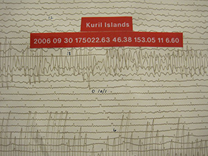
An analog seismogram
Pre-digital seismograms used to be recorded by a stylus with ink attached to an arm that drew lines along a scroll of paper. When the seismometer would register a vibration, the arm would oscillate and the stylus would draw a squiggle. Now seismograms are recorded as bits in a computer.
In the largest office space, two prominent screens display seismic waveforms scrolling in from the Global Seismographic Network, which IRIS also manages. The roughly 150 GSN stations are distributed around the world. Ahern points to parallel wiggles: “This is in Antarctica. This is a Venuzuelan station. Greenland. This one is Siberia. This one’s in Arizona.” Data from about 2600 stations globally, which include many IRIS-affiliated seismic networks, flow into the DMC in real-time, with only a few seconds’ delay. “There’s a small earthquake happening there,” Ahern indicates on the screen. “You can tell by the frequency [of the seismic waves] that these events are probably local, something close to the station. If they were distant, you’d see longer period waves, different frequency content. Also, if it’s a big earthquake, you’d see it on many stations.”
The employees at the DMC frequently glance up the tiled screens as if monitoring a sports game or stock market. They’re genuinely jazzed about earthquakes and they geek out about shifting landmasses.
“In 2004, the Sumatra earthquake ruptured a fault that was almost 1,000 kilometers long. That’s basically almost the length of California,” says Hutko, bouncing in his chair. “For the 2011 Japan earthquake, one thing that even surprised seismologists was that there were 50 meters of slip on that earthquake. That’s almost half a football field sliding past each other. And that extended for hundreds of kilometers! That’s pretty awesome.”
“The amount of energy released is incredible,” interjects Sharer.
“These great earthquakes are so large and they move so much mass that there’s actually measurable difference in the length of day,” says Hutko. “You and I wouldn’t notice on our watches, but physicists and geophysicists can calculate it.”
They aren’t flippant, however, about the destruction that follows in the wake of monster quakes. USArray has helped seismologists analyze how faults rupture and informed preparations for earthquake damage. Seismologists can’t predict earthquakes, but “give us a couple of hundred years’ time scale,” says Hutko, “and we’ll give you a percentage likelihood, which is actually useful for construction.” “The hazard assessment is extremely useful for society,” adds Sharer. “What we’re doing now is going to be mined for information for decades,” says Trabant. “Right now we’re laying the foundation for people to actually access it.”

