

109C
Camp Elliot, Miramar, CA, USA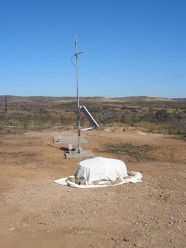
The USArray component of the NSF-funded EarthScope project ended its observational period in September 2021 and all remaining close-out tasks concluded in March 2022. Hundreds of seismic stations were transferred to other operators and continue to collect scientific observations. This USArray.org website is now in an archival state and will no longer be updated. To learn more about this project and the science it continues to enable, please view publications here: http://usarray.org/researchers/pubs and citations of the Transportable Array network DOI 10.7914/SN/TA.
To further advance geophysics support for the geophysics community, UNAVCO and IRIS are merging. The merged organization will be called EarthScope Consortium. As our science becomes more convergent, there is benefit to examining how we can support research and education as a single organization to conduct and advance cutting-edge geophysics. See our Joining Forces website for more information. The site earthscope.org will soon host the new EarthScope Consortium website.

By Maia ten Brink
How do we know what’s inside Earth? We can’t just cut into it like a cake. It’s extremely difficult to drill past Earth’s crust because the pressure and temperature increase the deeper down we drill. In fact, the deepest man-made hole ever only made it 12.3 kilometers, barely 1% of the 1,300-kilometer distance to Earth’s center.
Instead, seismologists measure vibrations at Earth’s surface in order to observe what is inside, just as doctors use x-rays to image the interior of the body without making any incisions. What provides the source for vibrations big enough to take a sonic “picture”? Earthquakes. When tectonic plates slide past each other, they release huge amounts of energy that ripple outward from the earthquake epicenter. Seismologists can determine what lies beneath Earth’s surface based on the time it takes for those seismic waves to reach seismometers in other parts of the world and changes to the wave amplitude that occur as the waves travel. By mapping these wave propagations, seismologists can then figure out what structures, rocks, and temperatures must exist beneath Earth’s surface to explain their observations.
The more seismometers scientists deploy on the surface, the clearer the images they can make of Earth’s interior. The Transportable Array (TA) is a network of seismometers spread every 70 kilometers across the United States that gives scientists a high-resolution look at the North American continent.
Dean Lashway is one of the field crew members who built over 2,000 seismic stations all over the United States as part of the USArray Transportable Array experiment. He sees seismology research from the technical, rather than theoretical, perspective. He helped roll the array from west to east across the continent, installing seismometers and then removing them after two years in order to re-bury them at new locations. Lashway is burly and bald-headed with glasses and a boyish smile. Before this job, he worked a contractor in Baghdad.
At the annual TA meeting, Lashway listened to seismologists talk about the discoveries they have made using TA data. He leaned over to another field crew member, shaking his head. “This data is Greek to me. Something happened seven billion years ago? How do they know that? Because of a hole we dug.”
Transportable Array field crew
Scientists like Göran Ekström, a seismologist at Columbia University, leave the fieldwork to Lashway and the rest of the TA field crew. Deploying seismometers and collecting data could take an individual scientist years working alone, so the Incorporated Research Institutions for Seismology (IRIS), which runs the TA experiment, shares data sets and data products with anybody who wants it. This principle of “open access” means that Ekström can download data from the TA to model Earth’s underlying structure while he sits in his office.
For Ekström’s research, the TA helps answer the question: What are the properties of the rock beneath the North American continent? “How thick is the Earth’s crust? What are the rocks that make up the Earth’s crust? What is the composition of the mantle rocks that lie beneath the crust, and what is the temperature of those rocks? Once you know that, you can start inferring the history of the continent,” said Ekström.
In 1998, Ekström helped propose the first plans for what would become the Transportable Array. Such a dense array of seismometers had never been attempted. “There was a lot of skepticism that any of this would actually work,” he said. One of the biggest concerns was how to transmit data collected by seismometers in remote locations back to data collection centers in California and Washington. “In the late 1990’s, the idea that you would have cell phone coverage in the less populated areas of the United States was not even thought as an option for collecting data.” Moreover, the whole project hinged on the kindness of strangers; each seismic site was hosted by landowners who agreed to participate for free in a government-funded science project.
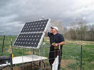
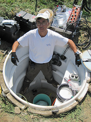
It did indeed prove challenging to pull off. TA manager Bob Busby tried to approach the project with a manufacturer’s mindset. Instead of employing graduate students and professors, he hired a specialized field crew. Lashway, on the construction team, dug holes at each station site. The install guys put together each station, with a 2.7-meter watertight vault containing a seismometer and several computers. The service technicians fixed up ailing sites, and the removal crew dismantled each seismic station at the end of its two-year lifetime and handed the parts off to the install crew.
Remote locations, weather, and technical failures made for a constant battle. The field crew members spent weeks or months at a time on the road, hauling supplies around the country. Most of them worked alone, and the annual TA meetings were one of the few times they got to interact face-to-face.
When they converged on Woods Hole, Massachusetts, in October 2013 for TA’s 10-year anniversary, the field crew guys had been feverishly installing the final 60 stations on the East Coast. They looked haggard but satisfied at completing their goal.
Over a lobster dinner, it was time to trade tales, some taller than others. Best state? Everybody liked the scenery in Montana and Wyoming. Worst state?
“Texas. I wrecked the truck. I almost died on that one,” said Lashway grimly. “I had a pickup truck. I’m towing a 6-meter trailer,” full of expensive seismic sensors and computers. “I hit black ice and the truck started moving like this.” Lashway snaked his hand in a side-to-side whip motion.
“I’m pumping the brakes and I’m working the trailer brakes to slow me down. So I straighten out and I’m heading over to the grass at the side of the median. As soon as the truck hit the grass, the trailer tilted and flipped. The lucky thing was that it broke the hitch, so the truck didn’t flip with it.”
He got out of the truck and called his supervisor. “It was thirty or forty-five seconds later, the semi hit and everything exploded. I was thinkin’ to myself, I would still be climbin’ out of that truck if that hitch didn’t break, and I’d have been dead.”
Transportable Array field crew member

