

I05D
Terrebonne, OR, USA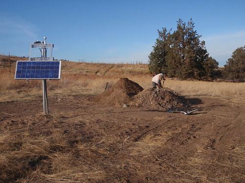
The USArray component of the NSF-funded EarthScope project ended its observational period in September 2021 and all remaining close-out tasks concluded in March 2022. Hundreds of seismic stations were transferred to other operators and continue to collect scientific observations. This USArray.org website is now in an archival state and will no longer be updated. To learn more about this project and the science it continues to enable, please view publications here: http://usarray.org/researchers/pubs and citations of the Transportable Array network DOI 10.7914/SN/TA.
To further advance geophysics support for the geophysics community, UNAVCO and IRIS are merging. The merged organization will be called EarthScope Consortium. As our science becomes more convergent, there is benefit to examining how we can support research and education as a single organization to conduct and advance cutting-edge geophysics. See our Joining Forces website for more information. The site earthscope.org will soon host the new EarthScope Consortium website.

Obtained under MRI award #0960275 from NSF, high frequency infrasound microphones (NCPA model IFS-4532) and a low to intermediate frequency microbarometers (Setra 278) have been included with EarthScope Transportable Array (TA) stations since 2010. These stations are currently being deployed in Alaska, where they are likely to operate until at least 2019. Over fifty TA stations throughout the network in the Lower 48 had Vaisala WXT500 series weather sensors installed, and through federal multi-agency cooperation weather sensors have been installed at nearly all remote stations in Alaska. Finally, adopted TA stations typically continue provide atmospheric data, including 159 under network code N4 that were operated as part of the Central and Eastern U.S. Network (CEUSN) by IRIS. In 2018, these stations were transferred to USGS for continued operation.
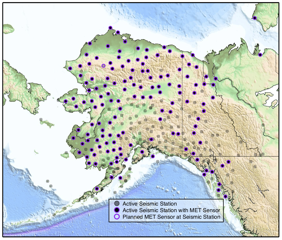
Locations of Meteorological (MET) sensors in the TA. Priority for co-located MET and seismic sensors was given to stations in remote areas that have not had meteorological sensor coverage before.
Atmospheric data recorded with these instruments have been used for geophysical research by investigators throughout the IRIS community. Recent examples include the study of bolides (meteors), atmospheric gravity waves, hurricanes, and other weather events (see references). Data can be requested through IRIS DMC using request tools such as the URL Builder to plot this example of the 2013 Chelyabinsk meteor burst as recorded on the TA station at Toolik Lake Research Station. More information on data access at the DMC is available here.
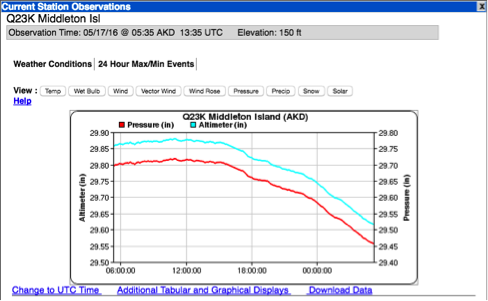
The MesoWest group at the University of Utah has greatly aided the dissemination of TA pressure data to the meteorological community. For several years, MesoWest has used IRIS webservice requests to obtain the 1 Hz LDO channel from the microbarometers, which are downsampled to a 5-minute average and displayed through the MesoWest website. MesoWest has also developed a graphical interface to visualize pressure data with other meteorological datasets, both for near real-time and archived data (link).
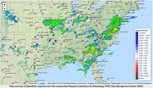
Atmospheric TA data as accessed through the MesoWest website.
In addition, MesoWest archives and curates the entire 1 Hz TA pressure data record in HDF5 format at the Research Data Archive (RDA) at the National Center for Atmospheric Research (NCAR) (Jacques et al., Submitted). MesoWest will update this dataset annually while TA stations continue to operate. The data is available to anyone with an RDA account, and has a DOI citation.
The National Oceanic and Atmospheric Administration (NOAA) incorporates real-time pressure observations from TA stations in Numerical Weather Prediction (NWP) models (link). Through MesoWest, these data are forwarded to the Meteorological Assimilation Data Ingest System (MADIS) at NOAA where data quality is assessed through spatial comparison to data from adjacent permanent weather stations. According to MesoWest, MADIS currently rejects an unusually high number of TA observations. This may be due to questionable calibrations on the reference stations, and MesoWest is working with NOAA to improve this process.
Other weather observations such as wind and temperature are less commonly used in NWP. Vaisala data may appeal to the National Weather Service (NWS), but as an all-in-one sensor there is concern because various weather observations are traditionally obtained from different heights, such as 2 meter for temperature and moisture and 3-10 meter for wind. Mounting Vaisala sensors consistently at 1.5-2 meter height would likely be acceptable. Because of the dearth of reliable weather observations in many remote areas of Alaska, near-real time atmospheric and meteorological data collected there will be especially high value to NOAA in the future. Stations with latencies greater than 30 minutes are unlikely to be consistently used in NWP, but will still be processed as part of MesoWest operations and forwarded along.
It remains to be seen how broadly the meteorological research community will utilize the TA data through MesoWest and NCAR for research purposes. In the future both organizations may be able to track access to the dataset similar to the logs provided by the IRIS DMC. Additional meteorological data collected at seismic stations may also be utilized by traditional IRIS users for investigations into site noise or seasonal signals.
All meteorological and atmospheric channels are archived under location code 'EP' and the following channel names. Sampling rates and units are noted here and in the metadata.
| Channel | Description | Samples/Second | Instrument |
|---|---|---|---|
| LDM | Absolute Barometric Pressure (hPA) | 1 | Q330 |
| LKM | Internal Temperature (ºC) | 1 | Q330 |
| LIM | Internal Humidity (%) | 1 | Q330 |
| LEP | Supply Voltage (V) | 1 | Q330 |
| LCE | Clock Phase Error Relative to UTC (usec) | 1 | Q330 |
| LCO | Oscillator Control Value | 1 | Q330 |
| BDO | Absolute Barometric Pressure (hPA) | 40 | Setra 278 |
| LDO | Absolute Barometric Pressure (hPA) | 1 | Setra 278 |
| BDF | Infrasound | 40 | Hyperion NCPA |
| LDF | Infrasound | 1 | Hyperion NCPA |
| LWD | Wind Direction (º) | 1 | Vaisala WXT |
| LWS | Wind Speed (0.1 m/second) | 1 | Vaisala WXT |
| LDV | Outdoor Pressure (0.1 hPA) | 1 | Vaisala WXT |
| LKO | Outdoor Temperature (0.1 ºC) | 1 | Vaisala WXT |
| LIO | Outdoor Humidity (0.1%) | 1 | Vaisala WXT |
| LRO | Rain Intensity (mm/hour) | 1 | Vaisala WXT |
| LRH | Hail Intensity (hits/cm^2/hour) | 1 | Vaisala WXT |
| LKH | Heater Temperature (0.1 ºC) | 1 | Vaisala WXT |
| LEH | Heater Voltage (0.1 V) | 1 | Vaisala WXT |
| LEW | Supply Voltage (0.1 V) | 1 | Vaisala WXT |
| LER | Reference Voltage (0.001 V) | 1 | Vaisala WXT |
References:
De Groot-Hedlin, C. and M.A.H. Hedlin (2014), Infrasound detection of the Chelyabinsk meteor at the USArray, Earth Plan. Sci. Lett., 402, doi: 10.1016/j.epsl.2014.01.031
De Groot-Hedlin, C. Hedlin, M.A.H., and K.T. Walker (2014), Detection of gravity waves across the USArray: A case study, Earth Plan. Sci. Lett., 402, doi: 10.1016/j.epsl.2013.06.042
Jacques, A.A., Horel, J.D., Crosman, E.T., Vernon, F., and J. Tytell, The Earthscope US Transportable Array 1 Hz Surface Pressure Dataset, Geoscience Data Journal (Submitted)
Tanimoto, T., and A. Lamontagne (2014), Temporal and spatial evolution of an on-land hurricane observed by seismic data, Geophys. Res. Lett., 41, doi: 10.1002/2014GL061934
Tytell, J., Vernon, F., Hedlin, M., Groot-Hedlin, C., Reyes, J., Busby, B., Hafner, K., and J. Eakins (2015), The USArray Transportable Array as a Platform for Weather Observation and Research, Bull. Amer. Meteor. Soc., doi: 10.1175/BAMS-D-14-00204.1

